
RealityCapture Tools: AI-classifier
The classification tool “AI-classifier” was introduced in RealityCapture with the version 1.1.0.12901-Blaze which was released in February 2020. It can be found in the “Tools” (Scene 3D) tab as AI-Classify.
To be able to use this tool a model must be created first. Without a model (mesh), this tool is going to be inactive, and you will not be able to press on tool’s button in the Tools tab. Regarding the model, it is not a requirement for it to be georeferenced, but better results will be achieved if the scale of the model is more realistic. When attempting to classify a model which is not georeferenced, a notification will show up to warn the user that the classification may not be correct. Nevertheless, it is still possible to classify that model.
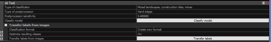
Before classifying a model, it is possible to use different settings. When the tool is used, the AI-Tool panel shows up in the lower left corner. Here you can find a few settings which can be changed to optimize the classification:
- Type of classificator – few options to choose here. This setting is based on the terrain that has been reconstructed.
- Type of postprocessor – a setting which helps to define the terrain. It can be set to none, if refining is not needed. Also it can be set to soft of hard edges based on the terrain.
- Postprocessor sensitivity – if the type of postprocessor is not set to none, then it is possible to set it’s sensitivity. This value can be set from 0 to 1. The lower the value, the more artificial objects RealityCapture is going to find.
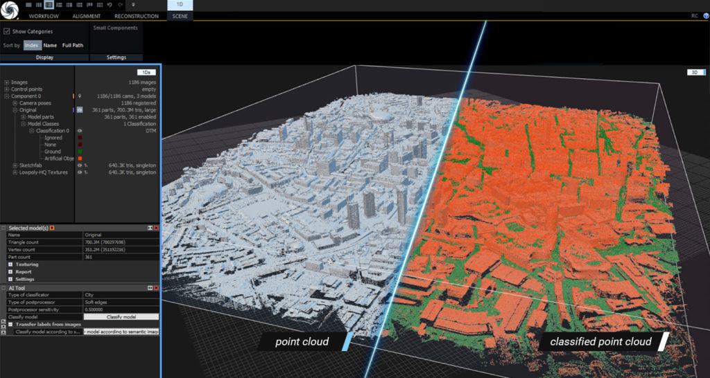
The classification tool in RealityCapture is still at its first phase, so there is room for improvement. There are two layers in which the model gets separated after the classification: ground and artificial objects. There are two more layers (ignored and none), but these layers cannot be edited in the post processing. The classification scheme follows the ASPRS Standard LIDAR Point Classes.
To edit a classification layer it should be selected in the 1Ds view under the model, which is displayed in 3D view (it can also be edited on the ortho projection, which is displayed in the 2D view). Use one of the selection tools from the Reconstruction tab to select a certain part of the model, which you want to override into a selected model and in the classification layer panel press on Override. This will change a selected part of the model into a selected layer. The classification can be exported as attribute with the pointcloud.
To create a DTM, an orthoprojection must be created first. In the orthoprojection tool you can choose to generate a DTM with the projection. The DTM can be based on already created classifications or you can set to create a DTM from a new one. Once the orthoprojection is created, it is possible to export the DTM (Digital Terrain Model) which is based on the classification in the selected orthoprojection.
Are you interested in a training for RealityCapture or do you need support for your projects? Feel free to contact us: info@3ds-scan.de
3ds-scan.de – your partner for photogrammetry & laserscanning